The Latest News from PA Chapter of APA…
Nowadays, planners are expected to know and use the latest and greatest technology, which is ever-changing and improving. Although new technology is not a panacea for every problem encountered in our day-to-day planning work, as it is often touted to be, it can be very useful for planners, expanding our understanding of local community context and problems. In this month’s newsletter, we focus on a few different aspects of technology, including a new technology and drone aviation park in Columbia, Central PA GIS Day, and the use of machine learning and big data to identify multimodal hubs in the Pittsburgh region. Enjoy!
 Planning Ethics: What’s New in 2022 and Elect Ethics Cases of the Year
The AICP Code of Ethics was recently updated in 2021 with the updated code going into effect January 1, 2022. This session will present a summary of the updated AICP Code of Ethics followed by a review of several ethical scenarios/case studies. The review of the updated AICP Code of Ethics will include a refresher on aspirational principles, rules of practice and behavior, and procedures for enforcement of the code. Key components of the AICP Code of Ethics that changed will be highlighted.
Ethic CM credit is pending approval. Deadline to register is December 1, 2022
If you’re interested in sponsoring a Webinar Wednesday session or have a session for Webinar Wednesday, please contact us. Send your request to info@planningpa.org.
Sustainability/Resilience, Equity and Ethics Distance Education Sessions
For APA members that still need sustainability/resilience, equity and ethics CM credit distance education sessions are available. The Planning Webcast Series, sponsored by APA Chapters & Divisions, are offering credit till the end of the year (12/31/2022). More information available online.
Presentations from the annual conference can be found on our website. If you do not see your presentation and wish to share it, please send them to info@planningpa.org
We look forward to seeing you next year in Scranton. We will be at the Hilton Scranton and Conference Center, save the date: October 15-17, 2023.
American Planning Association National Conference Update
The American Planning Association will hold its National Conference at the Philadelphia Convention Center, In-person: April 1-4, 2023 and Virtual: April 26-28, 2023. Stay up to date on conference news here.
Pennsylvania 2023 State Hazard Mitigation Plan Update – We Want Your Input
 Organizational and state representatives play a critical role in the plan update process. There are several ways to provide input to the plan. Please provide feedback by responding to the online survey, QR code or by downloading a PDF version of the survey.
Communication and Membership Committee
The Communication and Membership Committee is looking for volunteers to contribute articles for our monthly E-News. If you are interested or would like more information, please contact Amy Evans or Amy McKinney.
Each year the Chapter offers a scholarship to support individuals seeking funds for academic degree programs, internships, and professional development activities. If anyone would like to contribute to the Chapter’s Scholarship fund, donations can be made here. We accept all major credit cards, or you can send a check. Please make your check payable to “PA Chapter of APA Scholarship Fund” and mail it to P.O. Box 4680, Harrisburg PA 17111.
Conference Plenary Follow-up: Aviation Innovation and Redevelopment in Columbia Borough
If you attended APA PA’s Annual Conference in Lancaster in early October, you heard about an ongoing redevelopment effort in Columbia Borough during Tuesday’s plenary session. Afterward, several of our members wanted to know more, so we reached out to Columbia Manager Mark Stivers, AICP, who shared a wealth of information.
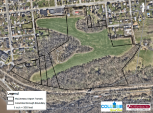
Aerial imagery and property boundaries for the McGinness site courtesy of Columbia Borough.
New plans for McGinness Innovation Park in Columbia Borough have their roots in the 58-acre site’s use in the 1940s as the private McGinness airport. As the last undeveloped property of any significant size in the borough, the McGinness tract is expected to play a major role in Columbia’s economic future and drive new revenue to support the long-term tax base. Since early 2020, borough staff have worked to acquire the land, identify and remediate environmental issues, and develop two conceptual reuse plans. In July of this year, the Commonwealth Finance Authority (CFA) awarded the borough and the Economic Development Corporation (EDC) of Lancaster County a multi-million dollar loan/grant package that will cover the costs of grading the site, building roads, and installing utilities.
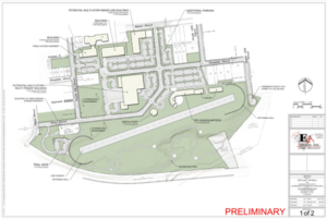
A preliminary concept plan featuring KATS and related uses courtesy of Columbia Borough.
A key partner in this work has been DR1 Group, a nonprofit organization that uses unmanned aircraft systems (UAS) technology to promote education, workforce development, scientific research, and public safety. DR1 plans to use the McGinnis site for the Keystone Aviation Training Center, or KATS. KATS aims to be Pennsylvania’s center-of-excellence for UAS, where public programs can operate alongside commercial endeavors and academic training – all focused on unmanned drone research, training, and development. As the centerpiece of a statewide initiative, KATS will connect government, industry, and academia to advance the use of unmanned technology in activities like package delivery and passenger transportation.
KATS’ design maintains McGinness’s original 1940s grass landing strip as a runway and provides space for hangars, a drone/helicopter port, and multi-story office and mixed-use buildings. Although the growth potential of an innovation park is clear, Columbia is not putting all of its eggs in one basket. An alternate concept plan provides for a variety of multi-use and multi-tenant buildings, including potential new residential units. Both concept plans blend seamlessly into the borough’s existing street network and include a walking trail through a nature preserve along with other recreational uses that provide benefits to residents beyond economic ones.
“Columbia has a rich history of cultivating industry and attracting residents to Lancaster County,” said council President Heather Zink in August of 2021. “By purchasing this property, the last large tract of land available in the borough, we feel we are in the best position to control redevelopment and usher in a new era for Columbia.” If you’d like to find out more, detailed plans and reports are available on the Borough of Columbia’s website.
 Central Pennsylvania GIS Day was held on Wednesday, November 16, 2022 at Harrisburg University of Science and Technology and virtually. The event had record-breaking attendance with over 300 attendees from across the Commonwealth, including over 70 high school students. Central PA GIS Day is tailored to introducing high school students in attendance to GIS as a career.
The day kicked off with a keynote address by Emily Mercurio of CivicMapper. a geospatial technology development company that creates solutions for climate, infrastructure, and social equity using the power of modern mapping technologies. During the day, attendees had the opportunity to participate in breakout sessions on topics ranging from using LIDAR data and 3D basemaps to modeling neighborhood segregation and utilizing GIS for historic preservation. A career panel discussion was held midday with leading GIS professionals from a variety of agencies and organizations. Attendees also had the opportunity to participate in hands-on activities including GPS field map activities and mini drone flying.
To learn more about Central PA GIS Day online.
Highlighting a Chapter Award Winner: SmartMoves Connections
At the October Chapter annual conference, the Southwestern Pennsylvania Commission received an award for their plan, SmartMoves Connections: A Regional Vision for Public Transit.
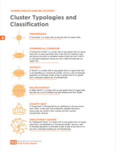
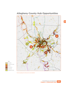
SmartMoves Connections represents an innovative approach to a regional transit plan. The plan put forth four core goals: identify locations for multimodal transit hubs, identify corridors for multimodal improvements, improve regional transportation coordination and involve riders and stakeholders in the planning process. The Team employed aerial photography that had been processed with machine-learning and was combined with Big Data origin/destination statistics to find Transit Supportive Land Use Clusters (TSLU) and Critical Corridors. The act of producing a TSLU map was unlike any other that has been deployed at the regional scale.
Computer simulations of the Multimodal Hub and Corridor treatments brought the concepts to life by showing how buses, bikes and people interact. The team then used a first-of-its-kind process where aerial photography data from Urban Footprint was analyzed to produce a map of TSLU clusters where multimodal potential could be inferred.
Some of the results of the SmartMoves Connections project are already coming to pass. The plan developed at the Transit Operations Workshop became the basis for a development proposal in Cranberry Township which includes a Multimodal Hub and new transit service. The Commission, Port Authority and PennDOT have applied for a major federal grant to build a bus only ramp from I-376 to the East Busway, much as described in the TranSystems simulation. SmartMoves is a well-organized plan with lots of case studies. It starts with clearly articulated goals and marches though points on how to get there. While it is specific for those responsible for implementation, it also asks the lay person what type of transit user you are and then describes how to make use of the plan, more online.