
The Latest News from PA Chapter of APA…
Public health is one of the foundational aspects of community planning and remains a critical issue today, although many planners do not have a clear picture of what they can do about community health. This month, we focus on a few different aspects of healthy communities, including health data collection, active transportation in Eastern Monroe, PennDOT’s transportation safety guidance, Walk with a Doc programs, and ward apportionment. Enjoy!

Advancing Racial Equity through Land Use Planning
Next Webinar Wednesday is Wednesday, September 7 starting at noon. To address present day challenges, this webinar will present examples of two cities addressing racial inequity through their land use planning tools & codes. The City of Minneapolis, Minnesota recently completed Minneapolis 2040, which reflects the result of more than two years of engagement with the people of Minneapolis. This engagement included over 100 meetings and conversations with thousands of residents, business owners, and others, where they shared their vision and hopes for the future of the city.
Equity CM credit is pending approval. Deadline to register is September 6, 2022
If you’re interested in sponsoring a Webinar Wednesday session or have a session for Webinar Wednesday, please contact us. Send your request to info@planningpa.org.
APA PA Annual Conference Registration is OPEN!
This year’s conference, “Forging Ahead: Adapting to Change!” takes place October 2-4 2022 in Lancaster. The Annual Conference will have over 45 concurrent sessions and six mobile workshops. Opening Keynote speaker is Mike Lydon and Pitkin Lecture speaker is Chris Leinberger. There will be sustainability/resilience, equity, law and ethic sessions available. Early bird registration is approaching, September 6, so don’t wait! You can pay by check or credit card. The last day to register for the conference is September 27 by noon.
There will not be onsite registration.
Each year the Chapter offers a scholarship to support individuals seeking funds for academic degree programs, internships, and professional development activities. If anyone would like to contribute to the Chapter’s Scholarship fund, donations can be made here. We accept all major credit cards, or you can send a check. Please make your check payable to “PA Chapter of APA Scholarship Fund” and mail it to P.O. Box 4680, Harrisburg PA 17111.
Congratulations to our 2022 Great Places
Great Public Spaces
- Etna Riverfront Trail and Park (Etna Borough/Allegheny County)
- Bull Run Greenway (Lewisburg Borough/Union County)
Great Greenways/Trails
- Delaware River Trail (Philadelphia)
- Fourmile Creek Trail at Wintergreen Gorge (Erie)
- Green Ribbon Trail and Preserve (Montgomery County)
October is National Community Planning Month
 The American Planning Association has developed a tool kit with materials you can use to promote planning throughout the month. Here’s the online link.
Please consider undertaking at least one of the following activities:
- Proclamation
APA has drafted a model proclamation to recognize the event. The model is designed so that it can be adopted by county and municipal governing bodies. You can request that the appropriate governing body/official adopt/approve the proclamation to designate October Community Planning Month in your county/municipality. You might also want to include the proclamation in your Planning Commission meeting agenda during October and then post the proclamation on the municipal, county, or regional website.
- LOGO and ADs
Post the logo for National Community Planning Month on your website.
- Social Media — #PlanningMonth
Use the hashtag #PlanningMonth in social media.
Any time and effort put forth in this endeavor to educate and publicize National Community Planning Month throughout Pennsylvania is greatly appreciated. The work that planners do to enhance the quality of life in Pennsylvania communities is important, and this provides an opportunity for that hard work to be recognized.
Communication and Membership Committee
The Communication and Membership Committee is looking for volunteers to contribute articles for our monthly E-News. If you are interested or would like more information, please contact Amy Evans or Amy McKinney.
Eastern Monroe Active Transportation Plan
The Monroe County Planning Commission received a 2019-2020 WalkWorks grant for the development of an active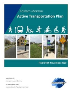 transportation plan for the East Stroudsburg Urbanized Area in eastern Monroe County. The plan was developed to explore opportunities to connect and raise awareness of the existing regional active transportation network, while identifying ways to improve pedestrian infrastructure. Ultimately, the active transportation plan’s goal is to improve public health, reduce congestion and air pollution, and provide equitable access to transportation.
Development of the Eastern Monroe Active Transportation Plan began in early 2020. A steering committee was convened, and Monroe County facilitated various stakeholder and public involvement activities during the plan development, despite the challenges encountered as a result of the Covid-19 pandemic.
The Eastern Monroe Active Transportation Plan was completed in November 2020. It includes a summary of the existing active transportation network within the East Stroudsburg Urbanized Area and identifies potential active transportation connections in each municipality within the study area. Cost estimates for each proposed connection, next steps for implementation and funding options were also included in the plan.
View the Eastern Monroe Active Transportation Plan
 Incorporating health and wellness opportunities wherever possible is an important job for planners. Walk with a Doc is an international organization with the goal of promoting community health through interaction between health professionals and residents. It was started by Dr. David Sabgir, a Columbus, Ohio cardiologist in 2005, to affect behavior change in his patients. Through a grassroots effort, this program has spread to over 500 chapters worldwide.
 It’s also a program being adopted by communities throughout the Commonwealth, with approximately 20 chapters from Pittsburgh to Philadelphia. In Susquehanna Township, Dauphin County, Walk with a Doc is a monthly event, with each month being led by a different doctor and focused on a different health topic. The walks last for about an hour and take place at different parks/venues around the Harrisburg area. The first portion of the walk is for residents to learn about a current health topic from the healthcare expert, while the rest of the walk is for open-ended conversation. The free Walk with a Doc program is an excellent low-cost tool to engage with the community and inform residents about important health topics. It also provides the opportunity for the community to highlight local trails and parks. More information can be found online.
Community Health Data Isn’t Just for Doctors
 With this month’s focus on planning for health and wellbeing, it is worth looking at two sources of data that professional planners can use to inform comprehensive plans, community development activities, housing policies, neighborhood design, recreational facility planning, and more.
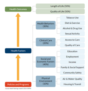
The Robert Woods Johnson (RWJ) Foundation maintains a comprehensive set of community health indicators for every US county. These County Health Rankings & Roadmaps combine data from many different sources into rankings for health outcomes (how healthy the community currently is) and health factors (community characteristics contributing to future health). These health factors include measures of the physical environment and social and economic circumstances that affect an estimated 50% of any given resident’s health. This is important to planners because we can directly influence many of these factors. It also offers an evidence-based approach to defining “quality of life,” something the planning profession often promises to improve but has difficulty systematically measuring.
A good place to start with the County Health Rankings is to explore Pennsylvania as a whole. From there, it’s easy to find a wealth of county-specific data. While you likely can obtain data from local sources that are more granular and/or cross-tabbed by gender, race, ethnicity, age, or other demographic factors, the RWJ ranking data provides a great first-look overview than can help you identify areas of community-wide concern and flag them for further investigation.
The County Health Rankings are useful in part because very few data compilations combine this range of sources into a user-friendly interface that promotes taking action on the data. One caution is to carefully review sources for the applicable date range and other caveats before drawing conclusions – the 2022 County Health Rankings, for example, include data from earlier years when more recent information is unavailable. The good news is that RWJ makes this metadata very easy to access. In fact, diving into the sources of rankings data can be a great way to identify little-known databases and dashboards on a variety of planning topics.
Community Health Needs Assessments are another good source of community data that planners often overlook. The Affordable Care Act requires that hospitals demonstrate overarching community benefit to maintain nonprofit status. An important component is the development of Community Health Needs Assessments (CHNAs) every three years. CHNAs are intended to drive strategic community initiatives addressing major health needs.
Of interest to planners, CHNAs focus not only on healthcare needs but also community stressors like rising home prices, food insecurity, violence, and trauma. CHNA methodologies vary by health care system but often combine extensive community polling with patient data on physical and behavioral health as well as social determinants of health. CHNAs are usually available online or by request to your local hospital system.

Economic hardship data from WellSpan Health’s CHNA, which covers a five-county service area in central PA. The full report is available online.
CHNAs demonstrate the impact of community stressors on individual wellbeing – stressors that planners often work to mitigate. This means that CHNA data can be used to make powerful statements about community need in our plans, to our elected leaders, and in the grant opportunities we pursue. If your community has a coalition of healthcare stakeholders, think about joining it. The potential partners you find there may be nontraditional, but it’s practically guaranteed that they’re trying to solve at least some of the same community challenges planners are.
Transportation safety is a key component of public health, and, nowadays, federal and state officials are putting a greater emphasis on safety-improvement projects in their funding and project selection. PennDOT’s Be Safe PA campaign provides an excellent summary of state efforts.
One problem is that many people don’t understand the rules or best practices for transportation safety, and this can make it challenging for planners to get support for active transportation improvements. Often, planners hear complaints from residents about cyclists and pedestrians and their use of local and state roads. In most cases, they are allowed to use the roads, but many drivers do not like this and consider them nuisances. It’s not just drivers who may not understand PennDOT rules, many pedestrians and cyclists don’t understand them either and may be unintentionally making their safety situation worse. Guidance for cyclists can be found online. And guidance for pedestrians can be found online.
Many local communities are refocusing on transportation health and safety, which is certainly not new for planners, but is welcome. Philadelphia’s Vision Zero effort is a great example of this type of initiative, which is particularly important with the rise in reckless driving.
Census data is a well-known tool in the world of planning, with many lesser known yet incredibly important uses. When thinking of redistricting, most people think of it at the federal or state level. However, First Class Townships that use a ward system must also undergo a similar process. After each census, ward lines need to be changed to minimize the variation in population between them. This is achieved by using data from the most recent census. Being a first-class Township, Susquehanna Township recently underwent this process.
To complete ward reapportionment in Susquehanna Township, an ArcGis Online web application was created. In addition, a reapportionment committee was formed, consisting of three Township Commissioners and the Township manager. The reapportionment committee worked to ensure a smooth process while being sure to include all relevant groups and stakeholders in the discussion. Once community engagement and stakeholder involvement were completed, the physical manipulation of ward lines could begin. On the technical side, the webapp was simple and allowed for Census Block Groups to be selected spatially, while also showing their populations. This user-friendly application allowed for the current wards to be changed spatially to meet the population variation requirements and for crucial communities of interest to be preserved. This is one of many unique ways ward reapportionment can be completed.
This is just an example of how reapportionment can be handled at the municipal level. As planners, it is important to be comfortable using data in ways that are unorthodox. By using tools such as GIS, redistricting is now a simpler and more transparent process than it was in the past.