
Posted on June 30, 2024
Planners on Vacation: Visiting the Puma City & Other Adventures in Incan Landscape Design
Governance / Working In PlanningBy Amy Evans, AICP
Inca cosmology divides the universe into three: the celestial world signified by the condor; the realm of earth by the puma, and the underworld by the serpent. Imagine then being Pachacutek, the ninth Sapa Inca of the Cusco chiefdom, at the start of his reign in 1438. Over several decades, Pachacutek and his successor expanded their territory from the valley around Cusco to encompass much of western South America, forming an empire known as Tawantinsuyu.
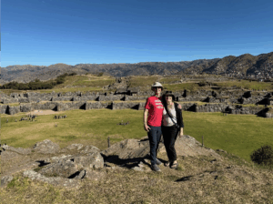
Two planners in front of the notable double zig zag walls of Saqsaywaman. Cusco lies in the valley, hidden from sight here, between the walls and the mountains in the background. Photo courtesy of the author.
As you may imagine, as Tawantinsuyu grew, Pachacutek felt that his capital of Cusco should reflect the wealth and importance of the territories it ruled: not only the four parts of Tawantinsuyu, but the entirety of the cosmos itself. His plan was a creative reshaping of the settlement to reflect the outline of a puma. Saqsaywaman, a set of large ceremonial structures on the hill above Cusco, was built as the head of the puma. A new square, called Hawkaypata, sat at the belly (some say heart). People of higher social class lived between Hawkaypata and Saqsaywaman, while others lived in the animal’s hindquarters. Four roads leading to the four quadrants of the empire met in Hawkaypata.
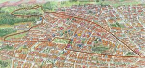
A map of Cusco for tourists illustrates the shape of the puma.
The Tullumayo and Saphi Rivers form the back and legs of the puma, respectively. The Q’orikancha, or sun temple, was the religious center of Tawantinsuyu and represented the puma’s reproductive organs, a creative force. The Inca viewed the Q’orikancha as lying at the center of 41 ceques, or sacred pathways, that radiate across Cusco’s surrounding valley. The ceques defined the location of numerous wakas, or shrines and other sacred sites.

Modern Cusco with Ausangate Mountain in the background. The city is now home to almost 500,000 people. Photo courtesy of the author.
I’m sad to say that before visiting, we didn’t realize just how closely the Inca forged connections between what they built and the natural and spiritual realms. Throughout our stay in Peru, we learned that many large structures and numerous small details are aligned to sacred symbols, sites, and settlements, as well as the movements of the sun, moon, stars and the Milky Way.
One of the things we did know before arrival is that the Inca had no written language and did not make use of the wheel. Another hallmark of the Inca quickly became clear: They flourished in incredibly difficult terrain (spend any time in Peru and you realize much of the country can be classified as difficult terrain). This was evidenced by our visit to Winay Wayna, the ruins of an agricultural settlement perched on earthquake-prone slopes that would cause modern farmers AND developers to seriously reconsider their plans.
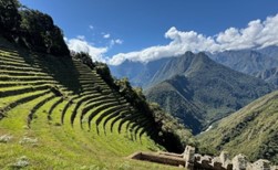
Winay Wayna’s agricultural terraces are near vertical in some places. Photo courtesy of the author.
Winay Wayna, besides being incredibly beautiful, is a master class in design and construction. Agricultural terraces that harness altitude-driven microclimates sit to one side, while residences and religious structures sit to another. Rock-lined channels supply water to homes, fountains, and terraces. It’s here that we saw smallish donut shapes carved out of stone, created to hold thatch roofs onto stone buildings. In other words, the Inca were clearly both geniuses in design and familiar with wheel shapes. In my not-so-scientific opinion, if the wheel had been useful in their environment, the Inca would have used them. Instead, they relied on foot travel with sure-footed alpacas as pack animals. This approach allowed them to maximize the productivity afforded by the eastern Andes in tune with their beliefs, in communities they could efficiently govern in times of peace and defend in times of war.
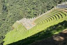
Winay Wayna’s residential and ceremonial areas. Photo courtesy of the author.
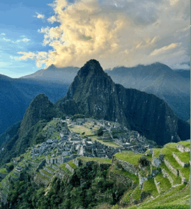
Sunset at Machu Picchu illustrates to me why the Inca may have held alignment with the sun so highly. Photo courtesy of the author.
Winay Wayna is relatively close to Machu Picchu, probably the most well-known Inca site of all outside of Peru. Although information about Machu Picchu is sparse, current thought holds it to be a seasonal estate built by Pachacutek. Machu Picchu’s physical location was likely chosen because of its alignment to other sacred sites in the area, as well as how the rays of sun at sunrise on the winter and summer solstices both land within the Torreon, a sacred ceremonial structure at the heart of Machu Picchu. Walter, our guide there, noted that it would have taken many years for observers to determine this location, given there are two chances per year to observe and clear weather is far from a guarantee at either time. Like many Inca sites, Machu Picchu is incomplete because Tawantinsuyu was still expanding in the 1530s, just as invaders from Spain arrived. Inca construction commonly took decades to complete in the best of circumstances and, as disease decimated the population and the Spaniards moved forward with conquest, construction often came to a halt while defense and finally survival became the focus.
While immediate ramifications for Tawantinsuyu were severe, Luis, our guide in Cusco, captured the long-term effects of the Spanish invasion on Peruvian culture quite well: “People like to ask me if I am Incan or Spanish. I tell them I am the child of winners and losers.”