
Posted on July 27, 2021
Delaware Water Gap National Recreation Area Visitor Use Management Plan
ArchiveDelaware Water Gap National Recreation Area Visitor Use Management Plan
The Delaware Water Gap National Recreation Area is a unit of the National Park System located in Eastern Pennsylvania and Northern New Jersey. Encompassing over 69,000 acres, the park is home to Dingman’s Falls, the second highest waterfall in Pennsylvania, 27 miles of the Appalachian Trail and 40 miles of the Middle Delaware National Scenic and Recreational River.
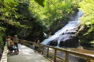
The Delaware Water Gap National Recreation Area receives over 5 million visitors annually and offers a variety of outdoor opportunities including 95 miles of trails, 216 picnic sites, 6 boat launches, 2 group campsites and 3 beaches. The park is also home to many cultural resources including 487 archeological sites covering over 500 acres. The Delaware Water Gap National Recreation Area operates year-round and provides a number of educational opportunities within the park.
In 2020, the Delaware Water Gap National Recreation Area adopted its Visitor Use Management Plan. The plan was developed over a 5-year period, with collaboration and input by neighboring town governments, elected officials, partners, communities, stakeholders, researchers, NPS staff, and the public. The plan is intended to guide the park in future decision-making by maximizing the ability of the National Park Service to encourage access, improve visitor experiences and protect the natural and cultural resources of the park and the river. The plan identifies existing conditions and issues within the park and identifies goals and strategies for maintaining the integrity of the park while allowing for visitor access. To learn more online about the Visitor Use Management Plan.